• Ahoy and Welcome to the New SSS Forums!!

    As you can see, we have migrated our old forums to new software. All your old posts, threads, attachments, and messages should be here. If you see anything out of place or have any questions, please scroll to the very bottom of the page and click "Contact Us" and leave a note with as much detail as possible.

    You should be able to login with your old credentials. If you have any issues, try resetting your password before clicking the Contact Us link.

    Cheers
    - Bryan

Hawaii to Washington

standardhuman

Dana 24 "Maris"
Has anyone sailed to the Pacific Northwest after Hawaii? I would love to discuss how this changes navigation of the High relative to sailing to SF or LA.

Thanks,
Brian
 
Paul Elliott did this on VALIS did this after the 2012 PAC cup
 
You might want to check with the Vic-Maui Race folks up in Washington. I assume most of their boats sail back to up that way after the race.
 
Brian,
Plenty of Hawaii racers head up to Seattle or beyond after finishing. It's not that uncommon. Jeanne Socrates sailed on to Sitka, Jim Fair to Puget Sound, etc. Most hard-core might have been Andy Evans whose Olson 30 was delivered to Victoria on her bottom.

As Thumper says, please keep your questions here if you don't mind.

Lucie
 
I hope to do that trip next time and spend a month or so cruising around up there and doing the Northern Century race. Yes, Rich and Edie sailed Andy's boat back in 2006 and had some issues (broken boom, etc.)

I'd expect the navigational issues to be similar to returning to SF - tracking the position and movement of the EPac High, and how much fuel you take determining how deep you want to cut through it to shorten the distance. Also, it tends to be light on the approach and Strait of JdF that time of year, so you'd want to keep more fuel in reserve for the end of the trip. Rich and Edie made the trip without an engine but as I recall it took a LONG time.

I'm anxious to hear more details from the experts.
 
Last edited:
Great tips Bob. I'm listening with great curiosity. Perhaps Peter might expand on cutting through vs. sailing around.
 
Last edited:
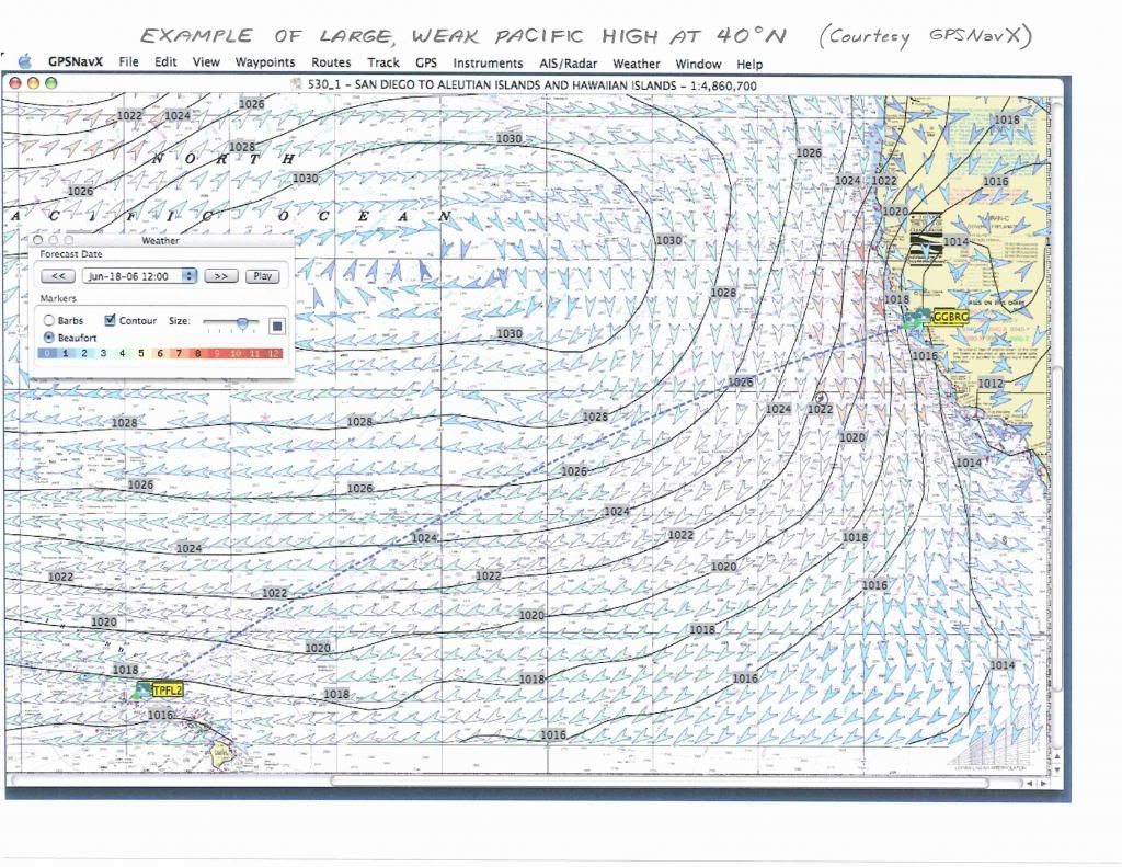
In the "a picture is worth a thousand words" category, here's the last page of my handout from the prior Return seminar. This is what the High looked like just before the start in 2006. Normally 40N might be enough coming back but not in this scenario! Fortunately for the return trip (but not good for the race) this High shrank and moved down, and I was able to come home along 38N right into SF. The return took only two days longer than the race.

You can see why the trip from HI to WA isn't that much farther than HI to SF - you have to go pretty far north either way.

EPacHigh40N2006.jpg
 
Last edited:
Everything that everyone has said makes good sense. Of the times I've made the trip, twice the high has been unavoidable and both times with weather routers advising, once in Dashews Beowulf and once in a Catalina 42. In both cases a lot of fuel was used, in the Catalina we were running on fumes when we got to Victoria. The best trip ever was in a hundred year old engineless pilot cutter (18 days to Tofino). I was never bothered by bad weather until after the 2010 PacCup when Jim Quanci told me I should expect one gale every time and every time since he said this I have had a gale. I always suspected that Jim sat on the right hand of God (and a little lower) but really. Returning last June we ran into a 972 low. Now tell me when in the history of the world there has been a 972 low in mid June in mid latitude Pacific. So here is my plan....leave Kauai and head north or as close as you are comfortable. By the time you are out of the trades it will usually get light for a couple of days, use fuel judiciously, but once you are past the horse latitudes it doesn't matter what you want to do because the lows and highs are USUALLY moving a lot faster than you can. As you head north you will eventually get into a westerly flow. Sometimes I haven't made any serious easting until I'm at the latitude of Winter harbour (top of Vancouver Island). After the PacCup returning with the crew from hell we were a lot closer to the Aluetians than to Hawaii or N. America. Best trip 17 days, worst trip 21 days. Strait of Juan de Fuca can really really blow hard in the summer (winter and spring and fall)but normally in summer it will be behind you (unless your Karma is particularly bad). I hope I don't sound like a complete idiot but basically go north until you're allowed to go east, then go east.
 
I'm definitely getting the picture now. Poring over good old fashioned pilot charts was also very helpful. I can probably safely carry about 106 hours of fuel. Is there somewhere near Hanalei to stock up on karma?
 
The Tahiti Nui (downstairs). BTW, do you know there's a Tahiti Nui in Pape'ete too?
 
Last edited:
I skippered the IP 380 Champ from Kauai to Seattle after the last SHTP. We had easterly trades up to 35 N and then had to motor north to 48 N 160 W. Dead north from Kauai. The high was huuuuge and no amount of diesel would have crossed it. Once we got to 48 N, we had brilliant sailing in westerlies, didn't start the engine again until 60 miles from Cape Flattery. Motored into Port Angeles for pizza and diesel and then pushed on to Puget Sound. Hawaii- PNW is a beautiful trip.

I have done 3 of the Hawaii- SF deliveries as well and have had good sailing on two of them, including a passage where we went up to 41 N and ran the engine for a grand total of 4 hours the whole delivery.

Things can definitely get variable and change, but a Hawaii to PNW delivery in summer is likely to be a very very nice sail that you will enjoy. Bring gear for Mahi Mahi and tuna and get ready to see some whales. The marine wild life north of about 42 N was absolutely spectacular.

edit- totally agree with what Peter said, but both times i did strait of juan de fuca in summer i had light air. Just sayin'. sounds like it can be a variable beast. a 972 low is f'ing nuts. We had 30-35 for 3 days, i don't remember if a low was over us and compressed the westerlies over the high or what. I think the Dana 24 will probably be a cool ride. It's an ambitious voyage but i support it fully. Tom Watson sailed his engineless triton from Hanalei to Neah Bay in 26 days in 2012. He got becalmed past Neah Bay in the STrait of JdF and towed into Neah Bay by the USCG, damaging his wind vane. And my cruising bot in Hawaii now started in tacoma. small boat voyages in the PNW rock. good luck on the Dana.
 
Last edited:
I'll just add one more thing. A reduction in speed (from top speed) when motoring of 10% can (on some boats) result in a reduction of fuel consumption of 30%. When I do get caught by a major high pressure area I just idle along at 3 or 4 knots in the direction that seems most helpful (ie not always on the rumb line). Psychologically it makes you feel like you're getting somewhere and, at least on my current boat, uses virtually no fuel. A lot of energy seems to go into 'wave making' as you approach hull speed but there are a lot of people on the forum that know more about this than me.
 
If sailing from Hawaii to cruise the Pacific NW, a possible alternative is as Stan and Sally Honey did on their Cal-40: sail to the top of Vancouver Island, clear at Port Hardy, then cruise inside Vancouver Island, mostly downwind, east and south through the Discovery Islands, Desolation Sound, and down the Straits of Georgia. Mileage and weather wise it's not much different than using Straits of Juan de Fuca as landfall. And avoids backtracking.
 
When I read the above post I immediately started to reply that Port Hardy is not a port of entry. I see however that there are customs and immigration at the airport so I suppose they do boats too. Good to know. Also you can get into Port Hardy under sail (if you anchor outside the inner harbour). That is something you can't do at Victoria or Sydney or even Nanaimo. Trust the Honeys to do it smarter.
 
I sailed back from Hanalei to Seattle on Idefix (Olson 30, no engine) in 2010. Our approach was to sail as close to the trades as comfortable and get no closer to the center of the high than the 1026 isobar, or something like that. The first three days were pretty bumpy close reaching in the trades, then things smoothed out and the boat was coasting along at about 6.5 knots close reaching under genoa in flat water and about 10kts of wind. We ended up sailing due North for about 1000 miles (to about 45 north) as the high kept moving North and West (it looked remarkably like Bob's picture, except a little more North). Eventually the wind clocked enough to let us turn in for shore, and a couple days later it clocked enough again to hoist a kite. There were three days of really light wind as we skirted the North edge of the High before it picked up again, and eventually we saw 25+ knots of breeze off the coast before it shut down completely for another three days, and thankfully picked up enough to give us a good run down the Strait. So exactly what Peter said. Go North until you can go East, then go East.

The total trip was 23 days, which I've been told is pretty ridiculously slow. Obviously having a very light boat was helpful in the light breezes we saw for most of the trip. I'd been told to expect rough weather, but it was all very mild, and a great trip overall. But it sounds like we may have been lucky (972 low? yikes!). The hardest part was watching the tropical blue water turn steely grey and the temperature drop a couple degrees every day.

Funny anecdote, we ran into a 50-ft cruising ketch in the light patch of wind on the North side of the High. They had left Hanalei five days before us, tried motoring through the High, and were down to about a gallon of fuel. We left them in our wake (after boarding them and drinking their rum, no joke) and figured we'd get to Port Townsend five days before them. Then we got becalmed 20 miles offshore and they used their last bit of fuel to motor past us.
 
Thank you all for the above information. Looks like Jack is coming back on her own bottom also. Thinking about taking 25 gallons of gas that should get me about 80 hours of motoring at 4.5 knots or about 360 miles if it is flat. Any thoughts on this idea?
Thanks
 
Back
Top