• Ahoy and Welcome to the New SSS Forum!!

    As you can see, we have migrated our old forums to new software. All your old posts, threads, attachments, and messages should be here. If you see anything out of place or have any questions, please click Contact Us and leave a note with as much detail as possible.

    You should be able to login with your old credentials. If you have any issues, try resetting your password before clicking the Contact Us link.

    Cheers
    - SSS Technical Infrastructure

New Boat 4 Sled

An event which has fascinated me for a number of years is the Texas 200.

http://www.texas200.com/

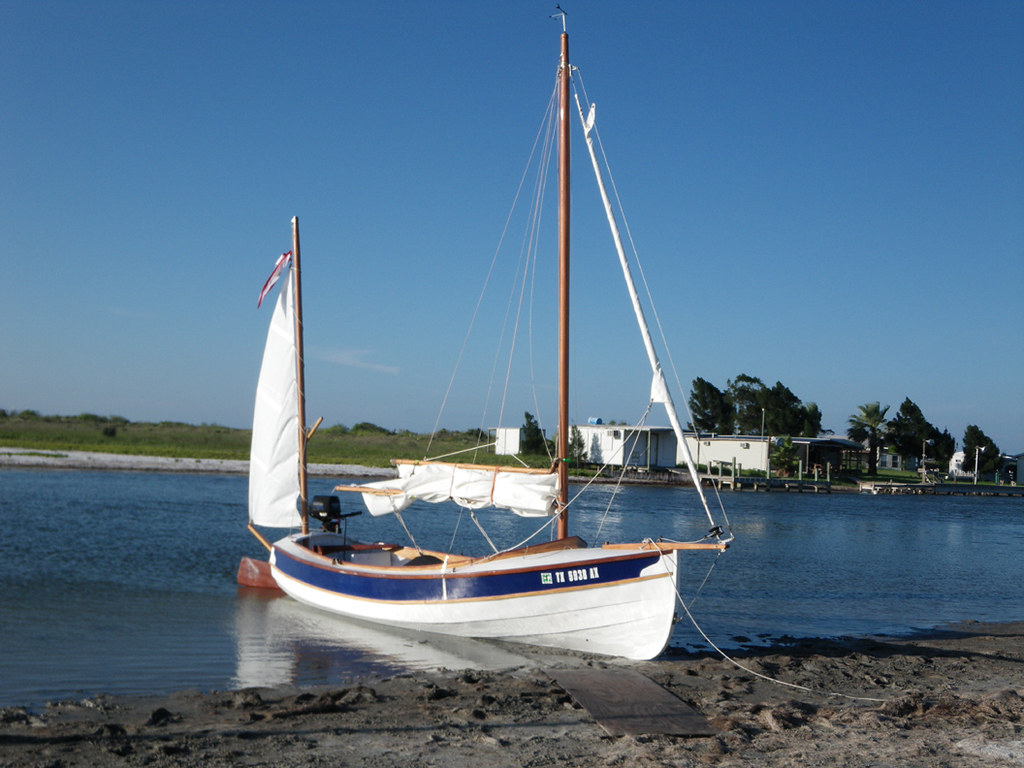
I really like the idea of "run what ya brung"....and the large number of alternatively designed, home-built boats that do the event. Sure there are lots of Hobie catamarans, O-Day daysailers and MacGregor 26s that do it. There are seemingly normal home-built boats like Goat Island Skiffs and Welsford Navigators that do it.

4747073827_ef99a45f51_b.jpg


1480694_845795178842534_7028545230883505521_n.jpg


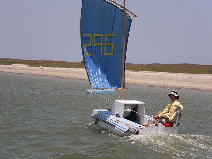
But there are also boats like these... a seriously customized Puddle Duck Racer, complete with built in chair, which I assume moves to the other side when you're on the other tack,but heck if I know. in 2014 a gaggle of Puddle Duck Racers did it.

texas-200-puddle-duck.jpg


10356170_10202099696885112_2858784450590793609_n.jpg


A lot of Jim Michalak (not my favorite designer, but whatever floats your....) boats have done it. One of those is the mayfly 14, which in fact I think is a pretty good-looking boat and perfect for this event.

024+-+Copy+(2).JPG


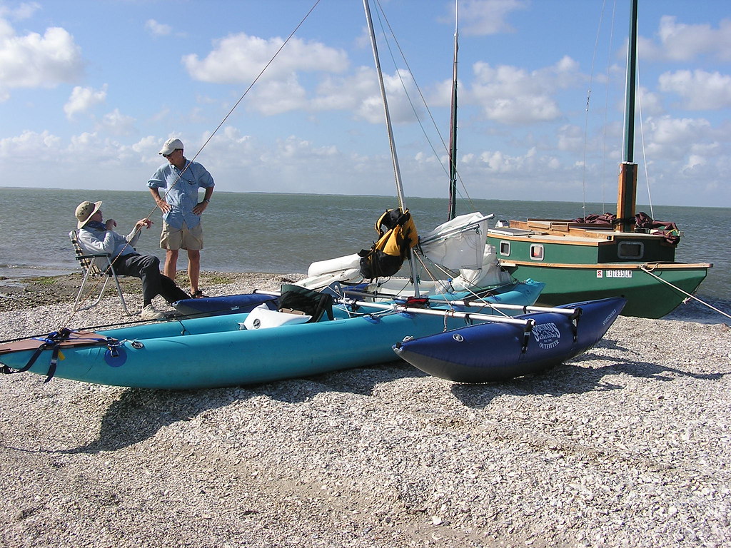
It's been done by guys in inflatable kayaks with inflatable pontoons.

2634672209_d796bdfde4_b.jpg


One of my favorite T200 boats is Andy Linn's "ooze goose", a 12 foot version of the Puddle Duck Racer, upon which he placed a cabin. To my eye, while the PDR's are just fugly, the damned goose actually looks pretty good.

http://andrewlinn.com/2012/120603_launch/index.htm

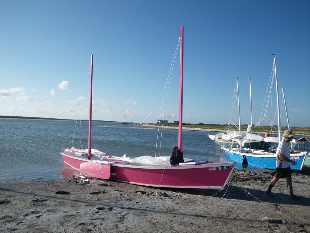
And then there's the famous incident where two guys cut out a Michalak boat at home and put the parts in their pickup truck. They drove to Texas, got there a couple of days early and assembled the boat. They painted it a shocking color. Then they sailed it 200 miles. They tried to sell it when they were done, but couldn't so they poured some gasoline on it and set it on fire. One of the builders, Andy Linn, has a penchant for setting boats on fire.

I'm not making this up. Here's the boat.... it's a "Laguna" by Jim Michalak, and actually I think it's a good boat for this event.

4747075745_9513f50b96_b.jpg
 
Last edited:
Ooze goose with the mizzen furled, old skool..REALLY old skool....

250859_3244812010347_924493536_n.jpg


AMF Sunbird 16 production boat that competed with the O'Day daysailer. There were a bunch of 15-17 foot daysailers with little cabins built in the 70's that tried to fit into this market.

484543_10150915756893226_1458281958_n.jpg


it is, truly, the perfect event for the MacGregor 26.

10403494_10203377654625426_1991677762124815016_n.j  pg


And just in case you thought I was kidding about setting the pink boat on fire after the event...

[video]http://s445.photobucket.com/user/jeadstx/media/PCTLT8M1Q6/Picture110.mp4.html?sort=3&o=0[/video]

=======

I was going to take the Skerry down there and do it, summer of 2015 but I let Joan talk me out of it. It's a three-day drive to Texas...a day to set up and meet everybody. Another day is spent moving the truck/trailer to the end point of the event and getting back for the shrimp boil dinner. Then it's four days to do the event. A day is needed to recover, tell lies and hang out, and then three days driving to get home. I probably should have done it, but the skerry was only marginally ready at that point.

There's a local guy who's done the event in a Mirror. The Mirror is a small pram-dinghy like an El toro, but 10 feet long instead of 8 and it has a lot more internal structure and flotation.
 
Last edited:
Drying out today after California's Central Coast, and Santa Cruz County in particular, felt the effects of three back to back storms over the last week that flooded homes, knocked out power and water, closed roads, and caused numerous land slippages.

The National Weather Service used descriptive terminology for these weather events, referring to an "atmospheric river," "AR," "firehose," and "Pineapple Express." The earth was already saturated, and it didn't take much wind or rain to topple trees and cause hillsides to slide. For a time, all roads into and out of Santa Cruz were blocked, including Highways 1, 35, 9, 17, 129, 152, and 101. Highway 17, the major artery over the Hill to Silicon Valley, remains compromised due to an active slide and rocks falling on the highway.

Here's a couple of short videos of the San Lorenzo River at flood stage. Check out the redwood trees floating downstream in swift current to the ocean.. Even the ducks sought high ground.
https://www.youtube.com/watch?v=4qx8PAQxboA

Capitola Beach was recipient of more timber as Soquel Creek also reached flood stage. AlanH: come and get your practice cabers and stones, they're easy to find.

IMGP0003.JPG

If you wonder why AlanH is seeking big poles (~22'x180 pounds) on the beach, and what he does with them, here's one visual explanation: https://www.youtube.com/watch?v=Ytcjy3Em_O8
 
Last edited:
Hi Sled --

We are considering a practice run from SF to Santa Cruz this weekend. Do you know if the harbor entrance is open for an 8 foot draft boat? I called the harbor office but have only been able to get the voice mail. Might have to change plans and go to Monterrey if Santa Cruz is closed out.

Thanks,
 
Hello Ian~
Howard Spruit here~
Skip is on a camping trip, not expected back until later in the week.
I have been monitoring the harbor mouth daily.
Yesterday the surf was flat and at High tide a 9 foot draft fishing boat powered out at High tide and radioed back he thought he rubbed the bottom.
The deepest part is close to the East Jetty.
The dredge is out of service due to a blown engine on the service tug.
I would say entering at this time with an 8' draft is marginal at best.
SO Monterey or Moss landing may be the smart thing to do.
I hop this helps.
Howard

Hi Howard --
Great info, I think we will pass on Santa Cruz. These newer boats do like bumping the bottom.

Thank you for the quick update.
 
Gentle Sailors,

In these times of tumult and tribulations, here's a fun (and challenging) geographical/nautical quiz. There are three sections, A, B, and C. The first correct answer to section A wins fish tacos at Olitas on the Santa Cruz Wharf. First correct answer to section B wins a delicious margarita at Olitas. And first to answer section C has the option for a yummy dessert also at Olitas. Ready, Set, Go!

~~~~~~~~~~~~~~~~^/)^^^~~~~~~~~~~~~~~~

The Central California Coast is incredibly spectacular, rugged, historical, and challenging to navigate, especially in small craft. Flippy recently visited a headland along this coast that gets doubled regularly by small boats northbound, much less often when sailing southbound.

This headland is distinguished by vertical bluffs, arch rocks, inaccessible coves, sea caves, sea stacks, a blowhole, a giant sinkhole accessible by kayak from waterlevel, and other wonders.

oliver2.jpg

oliver.JPG

oliver4.jpg

Inland from the headland are hills that have been occupied for 9,000 years. Currently the hills are home to only wildlife that includes badger, coyote, rattlesnake, cougar, bear, deer, bobcat, vole, ground squirrel, white egret, peregrine, golden eagle. There are also seals and sealions, abalone and otter near shore and a mountain of gold that yields its bounty to those who seek.

Once, on this headland, there was a Maine lighthouse with a fully operational Fresnel light. Today, the headland's skies are the darkest on the Central California coast. Southeast of the headland is a cove of the warmest water on the Coast, often 79-80 degrees. But no swimming, as the bluff trail stops short, past Windy Point and Rattlesnake Cove.

Enough clues. Question A: what is the name of this above described and photographed headland, or the park to its north?

Question B: Within view from this headland is a magnificent stone castle landmark, visible miles to sea on a clear day, guiding sailors to a sometimes safe harbor, but sometimes not. What is this landmark?

Question C: Australian actress, singer, and activist Helen Reddy nearly won an Academy Award singing a famous torch song on this headland ….what was the name of the musical she was leading actress in, on our mystery headland?

I regretfully must DSQ Howard Spruit who, in the early '70's beached his Hobie 14 on this headland when a plastic rudder pintle broke. Repairs were made on the small beach whence Howard completed his voyage.* Also, CHAUTAUQUA is DSQ as she grew up summers on this headland and shoreline, as her grandfather Oliver once owned and farmed the surrounding land.

* Howard recollects " I was not Racing. We were on a “Pleasure cruise”.The boat was a Hobie 14 and we were the only boat on this adventure. The surf was totally flat that day and the wind was a beam reach in both directions. The plastic rudder pintle on the port side sheared off so I sailed up to a wet sand beach at the base of a high cliff, the beach was about 20 feet wide and 50 yards long I replaced the pintle with a couple 3/8” bolts that I LUCKLY had in my tool kit."

"While on the beach we wandered around, ate our sandwiches, and discovered a small cave just above the high tide line. In that cave somebody had built a wall with concrete blocks from about 2’ off the floor to just overhead and about 3’ wide that damed off a freshwater spring and formed a small reservoir, at the lower end of this wall there was a water faucet with a porcelain handle, that had the word COLD written on it. I opened the faucet and indeed the water that came out was cold."

"There was no visible way to scale this cliff and the beach would be gone at High tide….. So there was a very dedicated soul out there with a tremendous sense of humor just trying to mess with my mind.
"
 
Last edited:
A: Piedras Blancas
B: Hearst Castle
C: Pete's Dragon (the song was Candle on the Water)

Excellent, BobJ! You have one correct answer, C, out of three, and won dessert at Olita's for identifying Pete's Dragon as the musical Helen Reddy was leading actress and Academy Award nominee on our mystery headland.

Anyone wanna win the fish tacos and/or margarita by correctly identifying the A: mystery headland/park, and/or B: stone landmark of safety/danger?

Hint: the ego of a famous movie actor was proximate cause of one of the most spectacular shipwrecks ever photographed in vicinity of the stone landmark.
 
Last edited:
BobJ is partially correct.

I know this place as not long ago I hiked along the bluffs. The giveaway hint is "...or the park to the north?" The sea stacks at Point Buchon are quite wonderful. I also have some history with the area from work I did nearby related to issues of coastal access.

Sled asked...
Question A: what is the name of this above described and photographed headland, or the park to its north?
Point Buchon is best accessed from Montaña de Oro State Park. Which, BTW, has a lovely campground.

Question B: Within view from this headland is a magnificent stone castle landmark, visible miles to sea on a clear day, guiding sailors to a sometimes safe harbor, but sometimes not. What is this landmark? I think BobJ was correct with Hearst Castle. The sometimes not so safe harbors are Morro Bay and San Simeon Bay. If you are ever at Morro Bay, look for the photos of the 82' Dittmire and Donaldson MOJO leaving when large swells were closing out the harbor entrance. And San Simeon Bay is not a safe anchorage during winter storms.

Question C: Australian actress, singer, and activist Helen Reddy nearly won an Academy Award singing a famous torch song on this headland ….what was the name of the musical she was leading actress in, on our mystery headland?
Disney Point is so named because a Disney picture, Pete’s Dragon, was filmed here in the 1970s. The beautiful shoreline played the role of Northern Maine on screen. A temporary lighthouse was built along the coast for the movie and was later removed.
 
Last edited:
Ok, the "Stone Landmark" is Morro Rock.

For a bit of fun, we have a lot of named "rocks" on our coast. I wonder how many are named "Bird Rock?" I have no answer. North of Point Piedras Blancas is "Harlech Castle Rock" named after a famous castle in Wales.
 
Last edited:
Congrats, DAZZLER, for winning the fish tacos and margarita at Olita's!

Point Buchon is exactly the stunningly lovely headland we recently visited. It is reached by road through Montana de Oro (Mountain of Gold) State Park (free admission.)

At the south end of Montana de Oro, so named because of its carpeted fields of yellow, orange, and gold wildflowers, lies the Pt. Buchon Trail. Permission to hike is granted Thursday through Monday by landowner PG&E, who also manages Diablo Canyon Nuclear Power Plant, 3.5 miles southeast from Pt. Buchon. At Diablo Canyon is a man made cove where cooling water is released from the two reactors, keeping the water temp at a balmy 79-80 degrees and the local marine life weird.

Diablo Canyon will stop producing power in 2025, and be dismantled, partly because it sits on top of the Hosgri earthquake fault. Less certain, except for huge cost overruns, are the upgrades that accidentally were installed backwards due to inadvertent reversal of construction blueprints....

Close by Pt. Buchon is "Disney Point", as DAZZLER describes, where a full on Maine lighthouse was built in 1977 for the film Pete's Dragon.

BuchonDisney.jpg

7 miles north of Pt. Buchon, at the end of a long sandspit, is the famous landmark Morro Rock, at the entrance to Morro Bay. This 581 foot high volcanic plug guards the northern side of Morro Bay Entrance and was the background for the spectacular Jan. 28, 1978, wipeout of the 82 foot motoryacht MOJO, chartered by actor George C. Scott to carry him and his actress wife up the coast to the Crosby Golf Tournament, where Scott had a tee time to meet despite warnings by the Morro Bay Coast Guard and Harbor Patrol not to proceed.

Here is Flippy contemplating the wave that took out MOJO:

Morro Bay 1.JPG
 
Last edited:
Apologies to all, especially BOBJ and DAZZLER, for inaccuracies in our recent Trip Report to Montana de Oro State Park, Pt. Buchon, and comments on Diablo Canyon Nuclear Power Plant.

BobJ is correct that Point Piedras Blancas, and nearby Hearst Castle at San Simeon, are entirely plausible answers to Parts A and B of the above quiz. Piedras Blancas did have a lighthouse with a Fresnel lens, and the lens is currently on display in downtown Cambria. Except during stormy weather, tours of Piedras Blancas light station are available, and the coast is equally spectacular as the Pt. Buchon headland and Montana de Oro to the south.

Note: President Barack Obama expanded the territory of the California Coastal National Monument January 12, 2017, adding Piedras Blancas and more than 6,000 acres to the monument area that includes islets, reefs and rock outcroppings spanning much of the state’s coastline.

piedras blancas 2.jpg

piedras blancas.jpg

Morro Rock, at the entrance to Morro Bay, has little to do with a "castle" landmark (except for perhaps the similarity in name to Morro Castle at the entrance to Havana Harbor.) My bad, and we will award BobJ the fish tacos and margarita, as well as DAZZLER.

Secondly, DAZZLER is intimately familiar with this section of coast, as well as Diablo Canyon, and I bow to his expertise and thank him for correcting my late night, loose cannon, approach to describing the area beyond the terminus of the Pt. Buchon Trail, land that is off limits to public access.

lethal force.jpg

Here is what DAZZLER has to say:

"I worked for PG&E from late 1986 to spring 1995. My first assignment was as "Site Architect" for Diablo Canyon. Basically, I was responsible for cleaning up what had been a long term construction site. I have a couple of comments related to your SSS post.

1. PG&E engineers designed the power plant. There are two reactors with associated steam turbine generators. One is a mirror image of the other. The "design mistake" was that they simply mirrored the drawings for the second reactor/generator. The result was that for all of the mirrored systems the thrust bracing was backwards, and the problem wasn't discovered until construction was underway. At that point Bechtel was brought in to re-engineer the system. Obviously, this caused increased costs.

2. As for the ocean temperatures at Diablo Canyon, I can't comment. I had the delight of getting to know the marine biologists who were monitoring the adjacent marine life and one of my projects was for a shore faculty to accommodate the scientist divers. There are two "heat exchangers" for the plant cooling water that isolate the nuclear generated steam from the ocean water.

I had great trepidation going to work for PG&E in 1986, and especially knowing that they were operating a nuclear power plant. As I became more knowledgable about the operation, I gained great respect for the high degree of care and professionalism exhibited by everyone at the plant. Within the company, the people at Diablo were top notch. Given the options, there are still many respected scientists that believe nuclear power is among the best options."

Back then I was involved in issues of coastal access to the PG&E controlled property. There were conflicting concerns that were not easily resolved. Given my history, I had long wanted to see more of the area. So, it's not surprising that not long ago we hiked the Pt. Buchon trail.
 
Last edited:
No worries Sled. Those questions were linked, such that one answer tended to eliminate answers to the others. I camped out too much on "castle" and was aware that San Simeon Bay only LOOKS like a good anchorage (etc.)

Before going to my office yesterday I drove to RYC and checked on the boat. All was well except I was going to my office afterwards. So I need to get outdoors today. I would head your way but many of the roads are damaged and another system is coming in later today.

I can't really complain - the extra tax-season hours recharge the boat kitty. My next big project is replacing the standing rigging. You may recall the J/92 has insufficient spreader sweep to get enough headstay tension in breeze (without over-flattening the main). Some owners have switched from wire to rod to be able to maintain rig tension, and I plan to do that.
 
Thanks to Cris Field (Todd), daughter of Hale Field of RENEGADE and Cal Cruising 46 fame, for helping enlighten us further on the history of Montana de Oro, Pt. Buchon, and the bluffs south to Diablo Canyon.

In 1942, Cris's grandparents, Oliver C. and Ruby Hale Field, acquired the Spooner Ranch, which included the lands from Montana de Oro State Park, south to the present-day boundaries of Diablo Canyon Power Plant. Also in the 1940s, the Fields constructed a small dam and pump house along Coon Creek, from which irrigation water was piped to agricultural fields downstream. These structures, and many other sites of historic interest, are visible today from the Point Buchon Trail.

Cris continues, "Our Rancho Pecho was named for the golden hills, and their obvious comparisons to glorious feminine anatomical endowment.

Panorama-FieldsRanch-small.jpg

The State's name "Montana de Oro" for the park to the north end of the 8,000 acres my grandfather once owned was a cleaned up version of the Spanish one. Actually the whole family owned parts of that. One side of the entry road we called the "His" because the men owned it and the other side of the road was called the "Hers". One of the all time great beach access roads at Hazard Canyon is on that stretch that the state acquired as a result of a condemnation suit against my grandfather, et al. This was at the same time that the main water rights to the ranch were compromised severely by PG&E's forced purchase of the other end of Pecho ranch at Diablo Creek. We still had access to the water source and had to travel thru PG&E territory to get to it but it squelched my Grandfather's vision for the distribution of the water rights for each of the family's selected parcels... not to mention gave my Grandfather a stroke which eventually was too much for him.

My association with that whole area goes back to before 1945, as I have photos to prove that I even visited the ranch as an unborn human being. My Dad proposed to my Mom on that Smugglers Cove beach in front of the Rangers Station which used to be the old main house. He used a shell with a hole in it and later replaced it with a ring. The newer house was built up on the hills in the center of the arc from Windy Point to Castle Rock... right around then.

The rather large shoreline mound of rock with caves right near the center of the ranch on the coast near Lion Rock we called Castle Rock. I remember climbing that to check out the tide to estimate when we could go get abalones without getting wet above our knees, and try to find the somewhat tame horses.

I could go on and on about all of the good times spent out there with the waves crashing over us, and hiking the high trails, wildflower sighting, working to help bring in alfalfa for winter feed, singing around the campfire in the outdoor entertaining area Grandpa had built near the house. Eating venison sausages made by grandpa from deer at the ranch. Visiting the family that raised the pigs near the gate at Coon Creek. Swinging from the big tire swings up at the pond at Diablo Canyon, clearing the road along the crest... I know I learned to drive out there in the ranch jeep; most of my generation did I think.

 
Last edited:
While awaiting the arrival of today's forecast "Atmospheric River," which may again cause evacuation downstream of Oroville Dam, it's a good time to contemplate local weather resources in addition to the National Weather Service, Cliff Mass, Windy-T, Passage Weather, and NOAA weather fax maps. (I don't have TV, nor use social media.)

For PG&E, and Diablo Canyon in particular, weather information, forecasting and measurement, is critical. Diablo Canyon has the best instrumentation and forecasters on the Central California coast, and they are publicly available and as good as it gets.

Here's the poop. In San Luis Obispo (SLO), next door to Diablo Canyon, John Lindsey is PG&E's go-to guy and prefessional marine meterologist. His analysis, forecasts, and up-to-minute measurements are the best, and available on the radio, e-mail, and online. The area covered extends north to at least San Francisco, and south to Southern CA.

John Lindsey's website: https://twitter.com/pge_john
 
Last edited:
Fun on a recent trip to Montana de Oro State Park/Morro Bay to visit with good friends Craig and Vicky Johnsen of nearby Los Osos. C&J continue to celebrate recent acquisition of their Iain Oughtred Sooty Tern design WEE BONNIE, and Craig was just finishing up a new hollow spruce mainmast he had built with sufficient coats of varnish.

Here is WEE BONNIE at the Morro Bay launch ramp:

WeeBonnie1.jpg

And beached on the Morro Bay sandspit for a picnic:

WeeBonnie2.JPG

Both Craig and Vicky are experienced sailors and navigators, with many ocean miles. In addition, Craig enjoys designing, building, and tweaking wood boats. They have recently sold their beautiful schooner MAGIC to the East Coast.

Craig tells us more about WEE BONNIE:

The Sooty Tern is a design by Iain Oughtred, an Australian who settled on the Isle of Skye, off the west coast of Scotland. It is the last and perhaps most refined in a design series he has created based upon his interpretation of a traditional Scottish near-shore double-ended fishing boat called a ”Yole”.

Iain designed his boats to utilize epoxy-glued lap construction using high-grade marine plywood for the planking, combining strength and lightness. These double-ended boats row very easily with a pair of 9-1/2’ oars and the rig can be set up or taken down in just a couple of minutes.

Like most of Iain’s design series, our WEE BONNIE utilizes an unstayed lug yawl rig. The Sooty Terns are 20’ long centerboarders, with a bit over 5’ of beam, a draft of less than a foot with the board up and probably weighs in about 350 lbs. (We have not weighed ours.) They are easily trailered and launch with a minimum of fuus from most ramps. As you saw, they can conveniently be stored in a side yard or longish garage. As a result of these features, the Sooty Terns have developed a following in a number of locales and are often used for beach camping cruises, especially in the PNW.

We named ours “WEE BONNIE” because of her Scottish heritage, her good looks and because she is noticeably smaller than our previous cruising boats. She was originally built in 2013 by a talented amateur builder in Victoria, BC. We purchased her last March and trailered her the 1200 miles back to the Central Coast. This past summer, after sailing her a few times, we began some minor upgrades and a completed refinishing of paint and varnish. There are a few more touches and tweaks to go before we have WEE BONNIE “just so”, but she is a lovely craft to see underway, a joy to sail and handles well in these local waters.

One picture is worth a thousand words. Here we go:

WeeBonnie5.JPG

WeeBonnie7.jpg

Sweet. Thanks to the Johnsen's for the photos of their lovely WEE BONNIE. We hope to see them soon at the Capitola Boat Club and Maritime Museum.
 
Last edited:
View attachment 2178

Sweet. Thanks to the Johnsen's for the photos of their lovely WEE BONNIE. We hope to see them soon at the Capitola Boat Club and Maritime Museum.

it was the Sooty Tern design that got me to wield a pen, and then the Carlson Design "Hulls" program, in order to design a small boat that made sense to me and was also pretty. Starting with the Sooty Tern, I soon discovered gunning dories.

Here's a gunning dory. They're primarily made for rowing and duck hunting.

GDa.jpg


Twiddling with the lines of the gunning dory to add more stability and righting moment, with the considerations of 1.) whatever I built had to fit in my front yard, diagonally 2.) anything that was to be covered under my homeowners insurance had to be <16 feet LOA and 3.) I could only build something about 15 feet if I wanted to use standard plywood sheets and only have one scarf in each hull panel

led me to the making of several cardboard models. When I was done, about 4 months later, I had a boat that I thought would work well, have a lot of the shape of Sooty Tern, the flat bottom and beach-stability of the gunning dory, and both row and sail reasonably well. Maybe two weeks after finishing my design and printing out the data points for laying out the hull panels on sheets of plywood, I discoverd that my boat had already been designed. John Harris of Chesapeake Light Craft had designed the Skerry, and all her dimensions were within an inch of what I had come up with. When the San Francisco Sea Scouts were donated a half-finished skerry, I bought her and finished her off.

The process started with falling in love with the Sooty Tern, though.

Here's the skerry, being rowed on launching day.

393616_3052442712496_530524955_n.jpg
 
Back
Top